Bhuj Earthquake-2001
The Republic Day, Bhuj Earthquake of 26 January 2001
The powerful earthquake that struck the Kutch area in Gujarat at 8:46 am on 26 January 2001 has been the most damaging earthquake in the last five decades in India. The M7.9 quake caused a large loss of life and property. Over 18,600 persons are reported to be dead and over 167,000 injured; the number of deaths is expected to rise with more information coming in. The estimated economic loss due to this quake is placed at around Rs.22,000 Crores (~US$5 billions).
The earthquake was felt in most parts of the country and a large area sustained damages.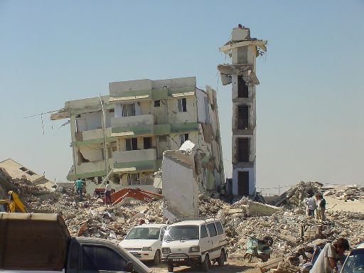 About 20 districts in the state of Gujarat sustained damage. The entire Kutch region of Gujarat, enclosed on three sides by the Great Runn of Kutch, the Little Runn of Kutch and the Arabian Sea, sustained highest damage with maximum intensity of shaking as high as X on the MSK intensity scale. Several towns and large villages, like Bhuj, Anjaar, Vondh and Bhachau sustained widespread destruction. The other prominent failures in the Kutch region include extensive liquefaction, failure of several earth dams of up to about 20m height, damage to masonry arch and RC bridges, and failure of railroad and highway embankments. Numerous recently-built multistorey RC frame buildings collapsed in Gandhidham and Bhuj in the Kutch region, and in the more distant towns of Morbi ( ~125km east of Bhuj), Rajkot (~150km southeast of Bhuj) and Ahmedabad (~300km east of Bhuj). At least one multistorey building at Surat (~375km southeast of Bhuj) collapsed killing a large number of people
.
Effect
The most important historical building is the Dabargadh (Maharajah's palace), which occupies a large site in the old town, and consists of a number of buildings, many with very fine architectural features and detailing (figures 1 & 2).


An interesting feature was a reinforced concrete façade probably built around the beginning of the twentieth century to support the masonry building behind it (figure 3). Although the reinforcement was severely corroded, the overall structure was holding well and there was no sign of earthquake induced damage.


There are already clear signs that reconstruction of the village has started, through self help efforts by the villagers themselves.


 a) Overview
 b) Detail
These buildings are three storeys, and the 450mm thick walls are in dressed good quality limestone masonry. The important rooms are as follows.
The room is at first floor level, and is 15m square on plan. The central area of the room (figure 14a) is approximately 12m square; it originally contained pools and fountains, and constituted the living area. A 2.4m wide open walkway (figure 14b) extends around the periphery of the room; the walkway is bounded externally by 450mm thick masonry walls and internally by a square grid of timber columns supporting the roof trusses, which span in two directions. The perimeter masonry walls rise about 3m above floor level, where they terminate, and are capped by a 2.4m wide roof slab above the walkway.


The structure of this part appears not to be seriously damaged, but is threatened by the collapse of unstable surrounding buildings. During the earthquake, however, many priceless paintings on glass fell from the walls and were irretrievably damaged.

Figure 17 shows that some were totally destroyed in the January 2001 earthquake, though interestingly some survived, despite their apparently rather unstable form, consisting of a heavy roof supported by unreinforced and effectively pinned masonry columns.


There is a stepped well in the town (figure 21), thought to date from the early 16th century, which is contemporary with the founding of the town, and predates construction of the artificial lake. In figure 21, the water level is about 6m below ground level. This is of a traditional construction found throughout Gujarat. The well was undamaged by the earthquake, and there were no reports of damage to any other stepped wells in Gujarat.

 a) External
  b)Internal


The Republic Day, Bhuj Earthquake of 26 January 2001
The powerful earthquake that struck the Kutch area in Gujarat at 8:46 am on 26 January 2001 has been the most damaging earthquake in the last five decades in India. The M7.9 quake caused a large loss of life and property. Over 18,600 persons are reported to be dead and over 167,000 injured; the number of deaths is expected to rise with more information coming in. The estimated economic loss due to this quake is placed at around Rs.22,000 Crores (~US$5 billions).
The earthquake was felt in most parts of the country and a large area sustained damages.
About 20 districts in the state of Gujarat sustained damage. The entire Kutch region of Gujarat, enclosed on three sides by the Great Runn of Kutch, the Little Runn of Kutch and the Arabian Sea, sustained highest damage with maximum intensity of shaking as high as X on the MSK intensity scale. Several towns and large villages, like Bhuj, Anjaar, Vondh and Bhachau sustained widespread destruction. The other prominent failures in the Kutch region include extensive liquefaction, failure of several earth dams of up to about 20m height, damage to masonry arch and RC bridges, and failure of railroad and highway embankments. Numerous recently-built multistorey RC frame buildings collapsed in Gandhidham and Bhuj in the Kutch region, and in the more distant towns of Morbi ( ~125km east of Bhuj), Rajkot (~150km southeast of Bhuj) and Ahmedabad (~300km east of Bhuj). At least one multistorey building at Surat (~375km southeast of Bhuj) collapsed killing a large number of people.
01: Introduction
•Gujarat, state, in western India, bordered on the northeast by Rajasthan state, on the east by Madhya Pradesh state, on the southeast by Maharashtra state, on the south and southwest by the Arabian Sea, and on the northwest by Pakistan
•The state covers an area of 196,024 sq km (The capital is Gandhinagar, on the outskirts of Ahmadabad, the former capital and largest city in the state.•The known history of Gujarat dates from about 250 BC. During the 4th and 5th centuries AD, it formed a part of the Gupta empire; it derived its name from the Gurjaras, who ruled the area during the 8th and 9th centuries
Effect
Technical Report: Effect of the Bhuj, India earthquake of 26 January 2001 on heritage buildings
This paper describes the findings of a tour of heritage buildings in the Indian state of Gujarat which were affected by the Bhuj earthquake of 26th January 2001. After a general introduction to the earthquake and its effects, a description is given of the damage suffered by princely palaces and religious buildings in Bhuj, JamNagar, Wankaner, Morbi, Maliya, Halvad, Dranghedra and Ahmadabad. 40 photos of the damage are included. The paper closes with conclusions and recommendations concerning the repair and maintenance of heritage buildings in Gujarat, and some observations on how the seismic response of massive masonry structures differs from that of engineered structures in reinforced concrete or steel. A modified version of this paper will be published in the EEFIT general report on the Bhuj earthquake.
Jamnagar
Jamnagar is about 100 km south of the causative fault, and the general level of damage in the town appeared to be around VII MSK. The earthquake was strongly felt and earthquake induced damage was relatively easy to find, but there was no severe disruption to the life of the city and few examples of collapses.The most important historical building is the Dabargadh (Maharajah's palace), which occupies a large site in the old town, and consists of a number of buildings, many with very fine architectural features and detailing (figures 1 & 2).
Figure 1: Dabargadh, Jamnagar - Darbar Hall
Figure 2 - Dabargadh, Jamnagar- carving detail
The buildings are thought to have been built over successive periods but the existing structures belong mainly to the seventeenth century. The site has been uninhabited for about 30 years and is in an advanced state of decay. Some portions had already collapsed before the January 2001 earthquake, which merely accelerated the process. The urgent need for the building is a general programme of restoration for the entire site.An interesting feature was a reinforced concrete façade probably built around the beginning of the twentieth century to support the masonry building behind it (figure 3). Although the reinforcement was severely corroded, the overall structure was holding well and there was no sign of earthquake induced damage.
a) Reinforced concrete strengthening façade b)Detail of corroded reinforcement
Figure 3: Dabargadh, Jamnagar- reinforced concrete strengthening façade
Starting at the end of the nineteenth century, the ruling family in Jamnagar built a number of large palaces on the outskirts of the old town. Two were inspected in some detail, namely the Amah Vilas and Pritap Vilas (figure 4). These are massive two to four storey buildings, in dressed loadbearing sandstone, but incorporating some steel joists supporting suspended floors.Figure 4: Pratap Vilas, Jamnagar
Both buildings were of good workmanship and had generally been adequately maintained. Ornamentation at roof level was extensively damaged (figure 5). There was some cracking in the load bearing masonry, particularly at upper levels, but generally the load bearing elements were stable and no part of the structure had collapsed. However, there was more severe structural damage at upper levels in at least two places (figure 6).Figure 5: Ornamentation fallen from roof level of Amah Vilas, Jamnagar
Figure 6: Cracking in Pratap Vilas, Jamnagar
Ranjit Vilas Palace, Wankaner
Wankaner is situated about 95km south of the fault. The main part of the town is on a plain extending north to the Gulf of Katchchh. Rocky hills outcrop to a height of several hundred metres on the southern boundary of the town. Damage levels due to the earthquake in the town appeared to be generally minimal, and this was confirmed by reports. A settlement of traditional buildings apparently of the type that was almost totally destroyed in and around Bhuj appeared undamaged (figure 7).Figure 7 - Wankaner - undamaged random rubble buildings
The palace is situated on top of a ridge on the rock to the south of the town (figure 8). The main building is a rectangular block of 2 to 3 storeys, with a central hall, circular corner turrets becoming octagonal and a square central tower on the north façade about 40m high. It is built from dressed masonry blocks, in basalt for the foundations and in local yellow and red sandstone for the superstructure. Floor construction is of timber and metal joists, carrying cast in situ mortar floors. Storey heights are around 6m. The building was completed in 1913, with some additions made 10 years later. The quality of construction is high, with the horizontal joints in the masonry very thin.Figure 8 - Ranjit Vilas, Wankaner
The main damage is at the roof terrace level. The corner turrets are both very severely damaged (figure 9) and the eastern baradari (single storey penthouse) has collapsed completely. Many of the balustrades of the terrace have collapsed. Figure 9: Ranjit Vilas, Wankaner - eastern corner turret
The central tower (figure 10) is square in plan. The walls are approximately 900mm thick, reducing above the third floor level, which reduces the mass and weight toward the top. The corner stones appear well keyed together, and the basic structure has not distorted or cracked significantly. At least two of the corners at different levels are braced with a short diagonal steel joist member.The dome on top of the central tower has collapsed, along with part of the clock and some stone work items, destroying two upper floors in the tower, and the steel trussed roof to the hall behind the tower on the upper level.Figure 10: Ranjit Vilas, Wankaner - central tower
The damage to the palace appears much greater than would be expected from that experienced in the town on the alluvial plain below. It is interesting to speculate whether the position of the palace at the top of a steep, rocky ridge gave rise to amplified seismic motions, or whether the ground motions were of a particularly long period. It appears that some mosques in the centre of the town were also damaged, but these were not inspected.Manimandir, Morbi
Morbi lies about 65 km SSE of the fault. Damage was quite evident throughout the town, with some sections (reported to be on soft ground) having extensive collapses. The town appears to have preserved many of its original features and character from a century ago (figure 11).Figure 11 - Morbi city gate
The Manimandir palace is a highly ornate building which dates from 1927 (figure 12). It consists of a quadrangular building very approximately 100m by 100m with a large central courtyard in which there is a temple. The main damage, which is extensive, is at roof level, particularly to the turrets which appear dangerously unstable.a) South and west external facades. Note temple projecting from within courtyard to left
b) Detail of damage to roof turrets
Figure 12 - Manimandir palace, Morbi
The old palace (dabargadh) was also reported to be extensively damaged (figure 13), though no inspection was carried out.a) External view
b) Internal view
Figure 13 - Dabargadh, Morbi
The main street and the Dabargadh, Maliya
Much of this village, which mainly consists of single storey random rubble masonry houses, has been severely damaged or has collapsed. It lies about 35km south of the fault. The dabargadh lies on the north western corner of the village. The older two storey random rubble masonry buildings of the dabargadh have completely collapsed. The newer two storey building, dates from around 1930, and is also mainly in random rubble masonry. It is severely damaged at first floor level particularly at the northern corners, and the single storey penthouse has completely collapsed (see figure), taking much of the first floor slab with it; what remains of the floor slab is precarious.The Dabargadh, Maliya
A massive eighteenth century masonry decorated entrance gate appears in reasonable condition, although a second similar gate (also apparently lightly damaged) was apparently demolished soon after the earthquake by a tenant of the former darbar, in order to gain access to some bank property.There are already clear signs that reconstruction of the village has started, through self help efforts by the villagers themselves.
Maliya - Self help reconstruction
Bhuj
Ayna Mahal Museum Complex
Bhuj was within 20km of the fault break, and suffered very severe damage. The palace complex is in the old walled city. It consists of a collection of buildings in a variety of styles, dating from the 18th century. Some of the buildings are of random masonry construction, and have suffered extensive damage and collapse.Collapse of Queens' Quarters, Bhuj City Palace
Part of the massive perimeter defensive wall to the complex has been damaged; in places, an additional skin of masonry thought to have been added as a repair after the 1819 earthquake has peeled away exposing the earlier wall beneath. The queens' quarters, to the east of the complex, has been devastated, and appears beyond repair. The areas occupied by the relatives to the north, are similarly devastated, and have been evacuated.a) Overviewb) DetailCollapse of City Wall, revealing ancient wall beneath
The inspection concentrated on the eighteenth century building to the east of the complex, which it is considered to contain some unique architecture of great importance. The curator of these buildings, which now function as a museum, Mr P J Jethi, acted as a very helpful guide and source of information.These buildings are three storeys, and the 450mm thick walls are in dressed good quality limestone masonry. The important rooms are as follows.
Fuvara Mahal (Hall of Fountains)
a) Description
The Fuvara Mahal or music room was used to perform Vraj Haveli Sangeet. The Lakhapatji Maharao (1752 -l761) made this hall in 1752.The room is at first floor level, and is 15m square on plan. The central area of the room (figure 14a) is approximately 12m square; it originally contained pools and fountains, and constituted the living area. A 2.4m wide open walkway (figure 14b) extends around the periphery of the room; the walkway is bounded externally by 450mm thick masonry walls and internally by a square grid of timber columns supporting the roof trusses, which span in two directions. The perimeter masonry walls rise about 3m above floor level, where they terminate, and are capped by a 2.4m wide roof slab above the walkway.
a) central living area
b) Internal view
Figure 14 - Fuvara Mahal, Bhuj - interior
The striking architectural feature is that the internal timber columns rise a further 3.2m or so above the top of the masonry walls and perimeter roof strip, to support a timber truss (figure 15) carrying a flat roof over the centre of the room. The vertical timber sides of the trusses have large openings, and form a clerestory. The roof trusses are unusual structurally, in that there are no horizontal ties at their base; some horizontal restraint is however provided at this level by the roof slab over the walkway acting as a ring beam. The trusses have bolted metal strap connections, which mean that they postdate the rest of the construction; their detailing also looks different. It is possible that they represent a repair after the 1819 earthquake, probably carried out in the mid nineteenth century.Figure 15 - Fuvara Mahal, Bhuj - roof truss and clerestory
The combination of the evaporative cooling effect of the pools and fountains, and the natural convection currents set up by the tall roof and clerestory was climatically designed to suit the hot summer months. These attractive and unusual features indicate that a high degree of importance should be placed on preserving the Fuvara Mahal.b) Present condition
Part of the north east corner of the perimeter walls, about 2m wide, have collapsed. The central three pairs of timber columns on the north side are tilted outwards (ie north) by about 5% to 7.5% (figure 14b), pushing the flat roof strip on this side about l50mm across the top of the external wall, which is also sloping outwards, but only by about 3%. The opposite wall is leaning by about the same amount in the same direction. The timber columns on all four corners of the grid are vertical; the other columns have a variety of tilts up to 2%, but usually much less. There is no evidence of structural distress in the timber columns; one member of the roof truss is bowed and slightly split at one point, but generally there is no other sign of structural distress or of material deterioration in the timber. The central roof slab has sagged very significantly, probably between trusses.Ayna Mahal (Hall of Mirrors) and Hira Mahal (Diamond Chamber)
These are situated on the first floor adjacent to the south side of the Fuvara Mahal; the Hira Mahal lies within the Ayna Mahal. They are both representative of exquisite craftsmanship adorning the traditional interior space, which was designed to create a climatically comfortable environment in a hot desert climate. The mirrors (pieces of mica) fixed on intricate patterns integrated with the structure increased the luminosity of the surfaces enhancing the brilliance of the ambient light which was allowed within the interiors to develop a soothing effect. Such halls of mirrors with jade were important features to display the wealth and prosperity of the princely families. This entire complex needs to be preserved as one of the very few such examples existing as a record of its era.The structure of this part appears not to be seriously damaged, but is threatened by the collapse of unstable surrounding buildings. During the earthquake, however, many priceless paintings on glass fell from the walls and were irretrievably damaged.
The upper floor of the southern part of the Fuvara Mahal comprises the Darbar Hall and an office room, situated directly above the Ayna Mahal & Hira Mahal. This part of the complex is extensively damaged and one of its walls is precariously hanging over the Fuvara Mahal, as mentioned previously. The roof is also very badly damaged, and the hipped end on the west side is already in a dangerous condition.
Pragmalji Mahal
This is a massive dressed masonry building thought to date from the l870's (figure 16), and is situated next to the older buildings described above. From an external inspection, extensive damage can be seen at the upper levels.Figure 16 - Pragmalji Mahal, Bhuj
Chatris (funeral memorials)
A collection of chatris, commemorating members of the ruling family in Bhuj, used to form an important part of the architectural heritage of Bhuj. They were built between ?1650 and ?1850; ?most predate the 1819 earthquake (dates to be confirmed). They are situated some distance from the palace complex described above, outside the old city walls.Figure 17 shows that some were totally destroyed in the January 2001 earthquake, though interestingly some survived, despite their apparently rather unstable form, consisting of a heavy roof supported by unreinforced and effectively pinned masonry columns.
Figure 17: Chatris, Bhuj
Halvad Palace
Halvad lies about 80km SE of the fault, and is situated on about 6m of alluvial material overlaying rock. Damage generally in Halvad is reported to have been moderate, although some surrounding villages were more seriously affected. The oldest part of the dabargadh dates back to the early 16th century. Figure 18 shows one of the buildings thought to date from around this time, which must therefore have survived a number of earthquakes, despite its apparently rather unstable structure similar to the chatris in Bhuj (section 6.5). Figure 18: Building in old part of dabargadh, Halvad. Column base detail shows evidence of rocking
An adjacent quadrangular two storeyed main building around a central courtyard was added approximately three centuries ago (figure 19). This newer part is adjacent to an artificial lake, which is probably contemporary, and is founded on about 12m of fill retained by a massive masonry wall. The structure of this new palace is masonry stone construction as an envelope to an internal highly ornate timber structure. In the centre of the courtyard is a seven storey octagonal tower (called the Victory tower) of stone masonry construction, some 20m high (figure 20).a) External from lake, showing retaining wall
b)Internal at 1st floor level, showing courtyard and timber arcade
Figure 19: Dabargadh, Halvad - main building
Figure 20: Dabargadh, Halvad - Victory Tower
The main building had suffered significant deterioration before the earthquake and some parts had been demolished. The timber roof of one section had been replaced by a reinforced concrete roof; this section survived well. Elsewhere, there were some further collapses, and damage to ornamentation and turrets at high level (see for example figure 19b). Three corner rooms at the first floor terrace level have developed severe vertical cracks in the masonry and in the north eastern corner the wooden stairs have precariously delinked from its bearing on the walls at terrace level. There is clear evidence that the ground beneath the terrace around the north west corner of the terrace has settled significantly. There are ambitious plans to renovate the palace complex and convert it into a centre for cultural studies.There is a stepped well in the town (figure 21), thought to date from the early 16th century, which is contemporary with the founding of the town, and predates construction of the artificial lake. In figure 21, the water level is about 6m below ground level. This is of a traditional construction found throughout Gujarat. The well was undamaged by the earthquake, and there were no reports of damage to any other stepped wells in Gujarat.
Figure 21 - Stepped well, Halvad, showing water level
Dhranghedra
Dhranghedra lies 20km east of Halvad and 115km west of Ahmadabad. It is founded on rock. The general level of earthquake damage in the town was moderate and reported to be less than in Halvad. The palace complex inspected (named Makhashraya Rajmahal) consists of three large linked buildings, namely Sundar Vilas, Surajmal and Ajit Niwas. The complex is a fine example of the intermingling of local craft and artistic traditions with European influences.Sundar Vilas
There is some severe cracking in this part, particularly at upper levels, but there appears to be no imminent danger of overall collapse. The domes are heavily cracked, and masonry panels over the windows in the dome have shifted outward significantly, and there is damage to ornamentation (figure 22). a) External b)InternalFigure 22: Sundar Vilas, Dhranghedra - dome
Surajmal
The central block consists of a Darbar hall, which extends for the full height of the building. It is flanked to the two longer sides, and to the north, by a series of smaller annex rooms with cross walls, and a passage running down the length of the external wall; these are on two levels. The walls are of dressed limestone masonry of high quality. The walls externally have bas relief carvings of eclectic styles which are of great architectural interest (figure 23).Figure 23: Darbar Hall Dhranghedra - bas relief showing the 'Britannic Deity' Queen Victoria
To the east and north, the original roof over the passageway and annex rooms has been replaced within the last 2 years by a flat reinforced concrete roof bearing on the top of the walls. The external walls here shown little sign of distress; the balustrades on the top of this eastern external wall have not toppled. To the west, the original timber truss roof supporting clay tiles remains. The top of the west wall has shifted outward by a few centimetres (figure 24). As a result, two of the roof trusses have fallen, and some of the others have shifted on their bearings. The balustrades and cornice on top of the centre portion of this wall have toppled. There are some signs of cracking in the central Darbar hall but no serious signs of distress.Figure 24: Surajmal, Dhranghedra - western corridor
Ajit Niwas
This is once again a building with a central porch and a central core of sets of rooms used for audience chamber as well as private areas, situated on two floors. There is a large periphery shielding this core and providing access ways to the private rooms. On a general level, the earthquake damage is on the upper floor peripheral areas where the structure of the building is badly shaken. The roof tops and parapets have tumbled and corner domed structures suffering separation and internal collapses of floors. The ground floor is comparatively unaffected by the earthquake, barring minor cracks at the crowns of many of the arches above doorways and windows.Ajit Niwas, Dhranghedra - north facade
Ahmadabad
Sarkhej
This is one of the most important Muslim sites in Ahmadabad, containing a number of buildings dating from the fifteenth century. Typically, the buildings consist of masonry columns supporting heavy domed masonry roofs. The earthquake caused limited damage to structures on a retaining wall around the large artificial lake which forms part of the complex; the damage may have been associated with movement of the retained soil. There was also some damage to the pavilion outside the Roza (figure 25) and limited damage to the main Friday Mosque. Overall, however, the site survived large unscathed.Figure 25: Sarkhej, Ahmadabad - Pavilion outside the Roza
Tomb of Sayed Usman at Usmanpura
This consists of a central dome with surrounding columns supporting a heavy masonry roof. Two columns supporting the SE portion of dome had collapsed due to the earthquake and it was evident that the earthquake had caused considerable movement of the columns supporting the roof around the dome; a few of these columns had cracked (figure 26).a) Overview b) Detail at cracks
Figure 26: Tomb of Sayed Usman at Usmanpura, Ahmadabad
Side Bashir's Minars near railway station
These two tall minars are called the shaking minars, because they have the feature that inducing sway in one minar causes the other to vibrate as well. They are over 30m high and date originally from the 10th century. The earthquake caused some cracking which had been temporarily restrained by steel rope (figure 27), but no serious damage.Figure 27: Side Bashir's Minars, Ahmadabad
Local Responce•The response within India was immediate. The national and state governments quickly provided assistance in many forms including cash, medical supplies, communications teams, shelters, food, clothing, transport and relief workers.•There were more than 185 non-government organizations (NGOs), mostly Indian charities, which undertook earthquake-related activities
International response
•The response within India was immediate. The national and state governments quickly provided assistance in many forms including cash, medical supplies, communications teams, shelters, food, clothing, transport and relief workers.
•There were more than 185 non-government organizations (NGOs), mostly Indian charities, which undertook earthquake-related activities
During Earthquake on indore
•Stay There! Do NOT Run Outside
•Stay Calm & Remember the Phase, “Duck, Cover, and Hold”
–Duck – And Look for Cover
–Cover – Under a Sturdy Desk or Table
–Hold – Onto the Furniture Leg Until Shaking Stops
Subscribe to:
Post Comments (Atom)
its very nice blog
ReplyDelete